1/8
Mgrs & Utm Map screenshot 0
Mgrs & Utm Map screenshot 1
Mgrs & Utm Map screenshot 2
Mgrs & Utm Map screenshot 3
Mgrs & Utm Map screenshot 4
Mgrs & Utm Map screenshot 5
Mgrs & Utm Map screenshot 6
Mgrs & Utm Map screenshot 7
Mgrs & Utm Map Icon

Mgrs & Utm Map

Dakik
Trustable Ranking Iconယံုၾကည္ရေသာ
3K+ေဒါင္းလုဒ္မ်ား
11.5MBအရြယ္အစား
Android Version Icon7.0+
Android ဗားရှင်း
7.2.5(11-01-2024)နောက်ဆုံး ဗားရှင်း
5.0
(1 ျပန္လည္သံုးသပ္မႈမ်ား)
Age ratingPEGI-3
ထည့္သြင္းပံု
1
ထည့္သြင္းရမည့္ဖိုင္ကို ေဒါင္းလုဒ္ဆြဲကာ ဖြင့္ပါ
2
Unblock AptoideAptoide is a safe app! Just tap on More details and then on Install anyway.
3
ထည့္သြင္းမႈကို ၿပီးေအာင္လုပ္ကာ Aptoide ကိုဖြင့္ပါ
app-card-icon
အေသးစိတ္မ်ားျပန္လည္သံုးသပ္မႈမ်ားဗားရွင္းမ်ားအချက်အလက်
1/8

၏ ရွင္းလင္းခ်က္ Mgrs & Utm Map

This application is GPS and coordinate systems helper especially for military personnel.


It is also a complete helper for mountaineering, trekking and hiking, cross running, scouting, hunting, fishing, geocaching, off-road navigation and all other outdoor activities and sports.


With satellite navigation systems such as GPS, GALILEO and GLONASS (GNSS) supported by your device and your sensors, you can see your most accurate position on different map layers.


Features:


* Easy and Faster

* Compass.

=> Compass on map (on the map that shows your direction)

=> Compass only (shows physical directions)

=> Angular units for compass (degrees and mil)

* Follow Mode

=> The center of the map follows your location while on the move.

* You can add and removing markers.

* Distance measure. (You can add custom route and calculate total distance)

* Area measure.(You can select an area on the map and calculate the area in square meters)

* You can see the altitude of your location.

* You can find the location according to Degree/Minute/Second , MGRS, UTM or Latitude/Longitude formats.

* Location (Coordinate) format options.

=> MGRS / U.S. National Grid (USNG) (WGS84/NAD83)

=> D°M'S" (WGS84)

=> Latitude/Longitude (WGS84)

=> UTM (WGS84/NAD83)

=> SK42(Gauss Kruger)

* Map type options (Road,Terrain,Satellite,Night Mode,Hybrid)

* You can share location coordinate.

* Distance unit options. (meter and feet).

* KML viewer. (Export and import KML layers).

ဤလျှောက်လွှာသည် GPS ဖြစ်ပြီးအထူးသဖြင့်စစ်ဘက်ဝန်ထမ်းများအတွက်စနစ်များကိုကူညီပေးသည်။


 တောင်တက်ခြင်း၊ တောင်တက်ခြင်း၊ ရေကူးခြင်း၊ ကင်းထောက်ခြင်း၊ အမဲလိုက်ခြင်း၊ ငါးဖမ်းခြင်း၊ geocaching၊ လမ်းမလမ်းလျှောက်ခြင်းနှင့်အခြားပြင်ပလှုပ်ရှားမှုများနှင့်အားကစားများအတွက်လည်းအထောက်အကူဖြစ်သည်။


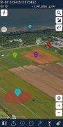
 သင်၏ကိရိယာနှင့်သင်၏အာရုံခံကိရိယာများမှထောက်ပံ့ပေးထားသည့် GPS, GALILEO နှင့် GLONASS (GNSS) ကဲ့သို့သောဂြိုလ်တုသွားလာမှုစနစ်များဖြင့်သင်၏တိကျမှန်ကန်သောအနေအထားကိုမြေပုံအလွှာများပေါ်တွင်တွေ့မြင်နိုင်သည်။


အင်္ဂါရပ်များ:


လွယ်ကူပြီးမြန်ဆန်သည်
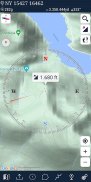
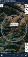
* သံလိုက်အိမ်မြှောင်။

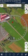
=> မြေပုံပေါ်တွင်သံလိုက်အိမ်မြှောင် (သင့်လမ်းကြောင်းကိုပြသည့်မြေပုံပေါ်တွင်)

=> သံလိုက်အိမ်မြှောင်သာ (ရုပ်ပိုင်းဆိုင်ရာလမ်းညွှန်ချက်များကိုပြသည်)
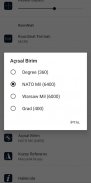
=> သံလိုက်အိမ်မြှောင်အတွက် Angular unit (ဒီဂရီနှင့် Mil)

* နောက်ဆက်တွဲ Mode ကို

=> မြေပုံ၏ဗဟိုသည်သင်သွားနေစဉ်သင်၏တည်နေရာကိုလိုက်သည်။

* သင်အမှတ်အသားများကိုထည့်သွင်းခြင်းနှင့်ဖယ်ရှားနိုင်သည်။

* အကွာအဝေးအတိုင်းအတာ။ (သင်စိတ်ကြိုက်လမ်းကြောင်းထည့်ပြီးစုစုပေါင်းအကွာအဝေးကိုတွက်ချက်နိုင်သည်)

* measureရိယာတိုင်းတာမှု (မြေပုံပေါ်ရှိselectရိယာတစ်ခုကို ရွေးချယ်၍ squareရိယာအားစတုရန်းမီတာဖြင့်တွက်ချက်နိုင်သည်)

* သင်၏တည်နေရာ၏အမြင့်ကိုတွေ့နိုင်ပါသည်။

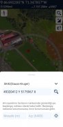
* သင်တည်နေရာကိုဒီဂရီ / မိနစ် / ဒုတိယ၊ MGRS, UTM သို့မဟုတ်လတ္တီတွဒ် / လောင်ဂျီတွဒ်အရသိရသည်။

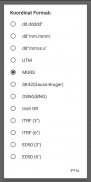
* တည်နေရာ (ညှိနှိုင်း) ပုံစံရွေးချယ်စရာများ။

=> MGRS / US National Grid (USNG) (WGS84 / NAD83)

=> D ° M'S "(WGS84)

=> လတ္တီတွဒ် / လောင်ဂျီတွဒ် (WGS84)

=> UTM (WGS84 / NAD83)

=> SK42 (Gauss Kruger)

* မြေပုံအမျိုးအစားရွေးစရာများ (လမ်း၊ မြေအနေအထား၊ ဂြိုဟ်တု၊ ညစနစ်၊ Hybrid)

* သင်တည်နေရာကိုသြဒီနိတ်ကိုမျှဝေနိုင်သည်။

* အကွာအဝေးယူနစ်ရွေးချယ်စရာ။ (မီတာနှင့်ပေ) ။

KML ကြည့်ရှုသူ (KML အလွှာများကိုတင်ပို့ပြီးတင်သွင်းပါ)


Mgrs & Utm Map - ဗားရွင္း 7.2.5

(11-01-2024)
အျခား ဗားရွင္းမ်ား
ဘာအသစ္ရွိလဲ* Horizontal display mode is available now .

သုံးသပ္ခ်က္ သို႔မဟုတ္ အဆင့္သတ္မွတ္ခ်က္မ်ား မရွိေသးပါ။ ပထမဆုံး ျပဳလုပ္ရန္အတြက္ ကို ထည့္သြင္းေပးပါ။

-
1 Reviews
5
4
3
2
1
Info Trust Icon
ေကာင္းမြန္ေသာအက္ပ္ျဖစ္ေၾကာင္း အာမခံသည္ဤအက္ပ္သည္ ဗိုင္းရပ္စ္၊ ေမးလ္၀ဲႏွင့္ အျခားမသမာေသာ တိုက္ခိုက္မႈမ်ားအတြက္ လံုၿခံဳေရးစစ္ေဆးခ်က္ကို ေအာင္ျမင္ခဲ့ၿပီး မည္သည့္အႏၲရာယ္မွ် မရွိပါ။

Mgrs & Utm Map - APK သတင္းအခ်က္အလက္

APK ဗားရွင္း: 7.2.5package: com.zahidcataltas.mgrsharita
အန္းဒ႐ိုက္ ကိုက္ညီမႈ: 7.0+ (Nougat)
ထုတ္လုပ္သူ:Dakikကိုယ္ေရးလံုၿခံဳမႈ မူ၀ါဒ:https://sites.google.com/view/dakiksoft/privacyခြင့္ျပဳခ်က္မ်ား:16
အမည္: Mgrs & Utm Mapအရြယ္အစား: 11.5 MBေဒါင္းလုဒ္မ်ား: 1Kဗားရွင္း : 7.2.5ျဖန္႔ခ်ိသည့္ ရက္စြဲ: 2024-02-01 19:42:32စခရင္အေသး: SMALLအေထာက္အပံ့ေပးနိုင္ေသာ စီပီယူ:
ပက္ေက့ဂ်္အိုင္ဒီ: com.zahidcataltas.mgrsharitaSHA1 လက္မွတ္: EE:BF:83:E8:B2:7C:E1:DD:D6:F2:46:C4:28:49:CA:C9:1C:29:D6:16ထုတ္လုပ္သူ (CN): Zahid ?atalta?အဖြဲ႕အစည္း (O): ေဒသဆိုင္ရာ (L): နိုင္ငံ (C): ျပည္နယ္/ၿမိဳ႕ေတာ္ (ST):

Mgrs & Utm Map ၏ ေနာက္ဆုံးဗားရွင္း

7.2.5Trust Icon Versions
11/1/2024
1K ေဒါင္းလုဒ္မ်ား6 MB အရြယ္အစား

အျခား ဗားရွင္းမ်ား

7.2.3Trust Icon Versions
28/8/2023
1K ေဒါင္းလုဒ္မ်ား6.5 MB အရြယ္အစား
7.2.1Trust Icon Versions
27/5/2023
1K ေဒါင္းလုဒ္မ်ား6 MB အရြယ္အစား
7.2Trust Icon Versions
9/5/2023
1K ေဒါင္းလုဒ္မ်ား6 MB အရြယ္အစား
7.0.1Trust Icon Versions
23/4/2023
1K ေဒါင္းလုဒ္မ်ား6 MB အရြယ္အစား
7Trust Icon Versions
18/2/2023
1K ေဒါင္းလုဒ္မ်ား6 MB အရြယ္အစား
6.6.1Trust Icon Versions
1/10/2021
1K ေဒါင္းလုဒ္မ်ား7 MB အရြယ္အစား
6.5.9Trust Icon Versions
16/6/2021
1K ေဒါင္းလုဒ္မ်ား7 MB အရြယ္အစား
6.5.8Trust Icon Versions
14/3/2021
1K ေဒါင္းလုဒ္မ်ား7 MB အရြယ္အစား
6.5.7Trust Icon Versions
27/1/2021
1K ေဒါင္းလုဒ္မ်ား7 MB အရြယ္အစား

က႑တူအက္ပ္မ်ား

သင္ႏွစ္သက္ႏိုင္သည္မ်ားမွာ...